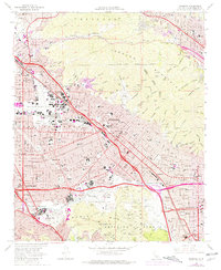
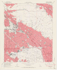
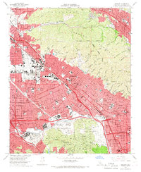
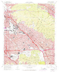
1966 Map of Burbank
USGS Topo · Published 1981About this map
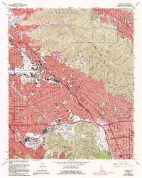
The entertainment capital of Southern California is in full view during the mid-1960s, documenting the dense urban expansion across the San Fernando Valley. Major production centers like the NBC-TV Studios, Warner Bros Studios, and Disney Studios anchor the media landscape in Burbank, while Universal City sits just across the Los Angeles River at the foot of the Santa Monica Mountains. The map reveals the intricate transport network of the era, from the established lines of the Southern Pacific RR to the surging reach of the Golden State Freeway and Hollywood Freeway.
Find a feature on this map
114 named features on this map. Tap any name to fly to it.
Don’t see what you’re looking for? This feature index may not catch every label — zoom into the map to look around manually.
Map Details
Editions of this 1966 Burbank Map
5 editions found
Other maps of this area

1894 · Los Angeles
USGS Topo · 1:62,500

1896 · Pasadena
USGS Topo · 1:62,500

1896 · Santa Monica
USGS Topo · 1:62,500

1898 · Santa Monica
USGS Topo · 1:62,500

1900 · Pasadena
USGS Topo · 1:62,500

1900 · Tujunga
USGS Topo · 1:62,500

1900 · Los Angeles
USGS Topo · 1:62,500

1900 · Fernando
USGS Topo · 1:62,500

1901 · Southern California Sheet No. 1
USGS Topo · 1:250,000

1902 · Santa Monica
USGS Topo · 1:62,500