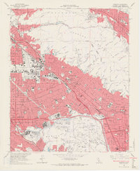
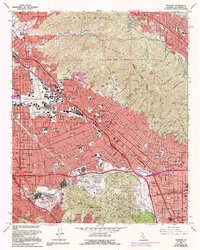
1966 Map of Burbank
USGS Topo · Published 1967About this map
Burbank and the surrounding San Fernando Valley are shown here in the mid-1960s, defined by the rapid suburbanization and industrial development typical of the postwar era. The presence of the Lockheed Air Terminal and major production hubs like NBC-TV Studios, Warner Bros Studios, and Universal Studios highlights the region's mid-century dominance in aerospace and entertainment. The landscape transitions from the dense street grids of Sun Valley and North Hollywood to the steep slopes of the Verdugo Mountains and Griffith Park. Major infrastructure projects like the Golden State Freeway and the Southern Pacific railroad underscore the area's role as a primary transportation corridor. Large memorial parks, including Valhalla Memorial Park and Forest Lawn Memorial Park, occupy significant land tracts, preserving the open space between the expanding residential blocks and the rugged foothills.
Find a feature on this map
114 named features on this map. Tap any name to fly to it.
Don’t see what you’re looking for? This feature index may not catch every label — zoom into the map to look around manually.
Map Details
Editions of this 1966 Burbank Map
5 editions found
Other maps of this area

1894 · Los Angeles
USGS Topo · 1:62,500

1896 · Pasadena
USGS Topo · 1:62,500

1896 · Santa Monica
USGS Topo · 1:62,500

1898 · Santa Monica
USGS Topo · 1:62,500

1900 · Pasadena
USGS Topo · 1:62,500

1900 · Tujunga
USGS Topo · 1:62,500

1900 · Los Angeles
USGS Topo · 1:62,500

1900 · Fernando
USGS Topo · 1:62,500

1901 · Southern California Sheet No. 1
USGS Topo · 1:250,000

1902 · Santa Monica
USGS Topo · 1:62,500