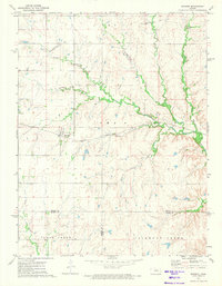
1972 Map of Burdick
USGS Topo · Published 1974About this map
Burdick serves as the primary rail-oriented settlement in this early 1970s landscape, situated along the Atchison Topeka and Santa Fe railroad line. The map highlights a rural infrastructure defined by its watercourses, most notably the meandering paths of Sixmile Creek, Diamond Creek, and Threemile Creek. These streams dictate the positioning of farmsteads and small-scale industrial sites, including a Quarry and scattered Gravel Pit operations.
Find a feature on this map
18 named features on this map. Tap any name to fly to it.
Don’t see what you’re looking for? This feature index may not catch every label — zoom into the map to look around manually.
Map Details
Editions of this 1972 Burdick Map
This is the sole edition of this map. No revisions or reprints were ever made.
Other maps of this area

1889 · Parkerville
USGS Topo · 1:125,000

1894 · Parkerville
USGS Topo · 1:125,000

1898 · Cottonwood Falls
USGS Topo · 1:125,000

1955 · Hutchinson
USGS Topo · 1:250,000

1957 · Hymer
USGS Topo · 1:24,000

1959 · Hutchinson
USGS Topo · 1:250,000

1970 · Lincolnville NE
USGS Topo · 1:24,000
1971 · Lincolnville
USGS Topo · 1:24,000

1972 · Wilsey
USGS Topo · 1:24,000
1972 · Delavan
USGS Topo · 1:24,000