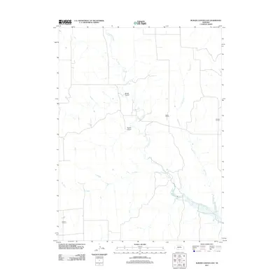
2011 Map of Burger Canyon East
USGS Topo · Published 2011About this map
Red Willow Creek winds through this section of Frontier County, carving a network of drainages that define the local topography. The landscape is marked by prominent natural features such as Burger Canyon and Kucera Canyon, which dictate the placement of rural roads and property boundaries. While the area is primarily defined by its watercourses, including Sand Creek and Dry Creek, evidence of long-standing community roots appears in the form of two distinct burial grounds: Saint Ann Cemetery on the eastern edge and Highland Cemetery in the southwest. A single small aviation facility, Beebe Airport, represents the modern infrastructure serving this sparsely populated agricultural region, where the section-line road grid adapts to the irregular contours of the canyons and creek beds.
Find a feature on this map
8 named features on this map. Tap any name to fly to it.
Don’t see what you’re looking for? This feature index may not catch every label — zoom into the map to look around manually.
Map Details
Editions of this 2011 Burger Canyon East Map
This is the sole edition of this map. No revisions or reprints were ever made.
Other maps of this area

1954 · McCook
USGS Topo · 1:250,000

1956 · Curtis SW
USGS Topo · 1:24,000

1957 · McCook
USGS Topo · 1:250,000

1958 · McCook
USGS Topo · 1:250,000

1970 · Red Willow Dam
USGS Topo · 1:24,000

1970 · Quick
USGS Topo · 1:24,000

1970 · Burger Canyon SE
USGS Topo · 1:24,000

1970 · Burger Canyon East
USGS Topo · 1:24,000

1973 · Camp Hayes Lake SE
USGS Topo · 1:24,000
1973 · Beverly
USGS Topo · 1:24,000