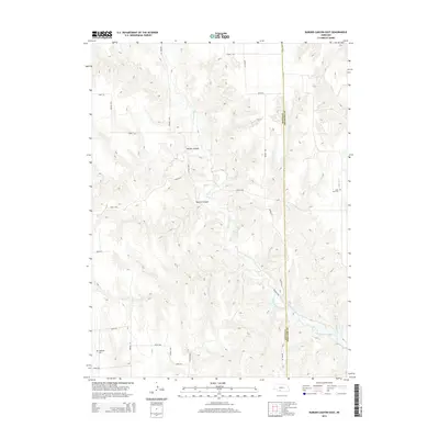
2014 Map of Burger Canyon East
USGS Topo · Published 2014About this map
The border of Frontier and Hayes counties in Nebraska is defined by a landscape of intricate drainages and rolling uplands, where the Red Willow Cr system carved deep incisions into the prairie. This topography is dominated by local landmarks like Burger Canyon and Kucera Canyon, which showcase the erosive power of seasonal watercourses in this portion of the Great Plains. The map reveals a sparse human footprint, primarily organized along a rectilinear grid of section roads including Road 735 and Avenue 377. For those researching local history, the map serves as a record of early community sites, notably the Saint Ann Cem on the eastern edge and Highland Cem in the southwest corner. These burial grounds, alongside drainage names like Sand Cr and Dry Cr, provide the primary markers for the rural farmstead network that settled this portion of the state.
Find a feature on this map
23 named features on this map. Tap any name to fly to it.
Don’t see what you’re looking for? This feature index may not catch every label — zoom into the map to look around manually.
Map Details
Editions of this 2014 Burger Canyon East Map
This is the sole edition of this map. No revisions or reprints were ever made.
Other maps of this area

1954 · McCook
USGS Topo · 1:250,000

1956 · Curtis SW
USGS Topo · 1:24,000

1957 · McCook
USGS Topo · 1:250,000

1958 · McCook
USGS Topo · 1:250,000

1970 · Red Willow Dam
USGS Topo · 1:24,000

1970 · Quick
USGS Topo · 1:24,000

1970 · Burger Canyon SE
USGS Topo · 1:24,000

1970 · Burger Canyon East
USGS Topo · 1:24,000

1973 · Camp Hayes Lake SE
USGS Topo · 1:24,000
1973 · Beverly
USGS Topo · 1:24,000