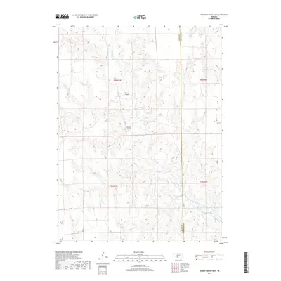
2017 Map of Burger Canyon East
USGS Topo · Published 2017About this map
Red Willow Cr meanders through the dissected plains of southwestern Nebraska, defining the deeply carved topography of this Frontier County landscape. The drainage network is characterized by prominent landforms such as Burger Canyon and Kucera Canyon, which drop toward the creek beds from the surrounding high ground. This area, located near the boundary with Hayes County, is sparsely populated, with land use primarily oriented around the creek valleys. Evidence of earlier settlement is found at Saint Ann Cem in the eastern portion of the quadrangle and Highland Cem to the southwest. A grid of rural routes, including RD 732 and RD 379, provides access across the rugged terrain, following the section lines of the Public Land Survey System.
Find a feature on this map
20 named features on this map. Tap any name to fly to it.
Don’t see what you’re looking for? This feature index may not catch every label — zoom into the map to look around manually.
Map Details
Editions of this 2017 Burger Canyon East Map
This is the sole edition of this map. No revisions or reprints were ever made.
Other maps of this area

1954 · McCook
USGS Topo · 1:250,000

1956 · Curtis SW
USGS Topo · 1:24,000

1957 · McCook
USGS Topo · 1:250,000

1958 · McCook
USGS Topo · 1:250,000

1970 · Red Willow Dam
USGS Topo · 1:24,000

1970 · Quick
USGS Topo · 1:24,000

1970 · Burger Canyon SE
USGS Topo · 1:24,000

1970 · Burger Canyon East
USGS Topo · 1:24,000

1973 · Camp Hayes Lake SE
USGS Topo · 1:24,000
1973 · Beverly
USGS Topo · 1:24,000