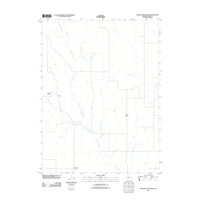
2011 Map of Burger Canyon West
USGS Topo · Published 2011About this map
Blackwood Creek and its tributaries define the drainage patterns of this Hayes County landscape, where the agricultural grid is interrupted by the rolling breaks of Government Canyon. This 2011 survey documents the rural character of the region, anchored by established sites of local heritage such as the Pleasant Ridge Cemetery and the German Evangelical Cemetery. The water network, including Skunk Creek and Little Blackwood Creek, provides a clear view of the natural topography that shaped early settlement and road placement. Traces of previous infrastructure remain visible in the alignment of Old Hwy 17, offering researchers a look at how transportation corridors have shifted or persisted over decades of prairie farming.
Find a feature on this map
7 named features on this map. Tap any name to fly to it.
Don’t see what you’re looking for? This feature index may not catch every label — zoom into the map to look around manually.
Map Details
Editions of this 2011 Burger Canyon West Map
This is the sole edition of this map. No revisions or reprints were ever made.
Other maps of this area

1954 · McCook
USGS Topo · 1:250,000

1957 · McCook
USGS Topo · 1:250,000

1958 · McCook
USGS Topo · 1:250,000

1970 · Burger Canyon SE
USGS Topo · 1:24,000

1970 · Burger Canyon East
USGS Topo · 1:24,000

1973 · Camp Hayes Lake SE
USGS Topo · 1:24,000

1973 · Palisade
USGS Topo · 1:24,000
1973 · Beverly
USGS Topo · 1:24,000
1973 · Burger Canyon West
USGS Topo · 1:24,000

1974 · Hayes Center
USGS Topo · 1:24,000