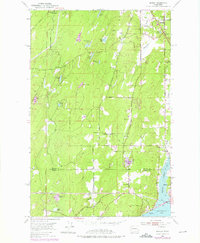
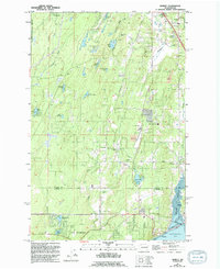
1953 Map of Burley
USGS Topo · Published 1976About this map
Burley Lagoon and the northern reaches of Henderson Bay define the southern edge of this mid-century survey of the Kitsap Peninsula. The landscape is characterized by a dense network of freshwater bodies, including Horseshoe Lake, Square Lake, and Stansberry Lake, set within terrain divided by the Willamette Meridian. Small communities like Burley, Purdy, and Wauna cluster near the tidal waters, while inland settlements such as Glenwood and Sunnyslope are connected by a growing system of local routes like Glenwood Road and Sidney Road. The map records a period of local transition, noting the Port Orchard Airport and several gravel pits, alongside older landmarks like Bethel Church. This documentation is particularly valuable for tracing the development of the Kitsap and Pierce County line before the significant suburban expansion of later decades.
Find a feature on this map
39 named features on this map. Tap any name to fly to it.
Don’t see what you’re looking for? This feature index may not catch every label — zoom into the map to look around manually.
Map Details
Editions of this 1953 Burley Map
6 editions found
Other maps of this area

1936 · Point Misery
USGS Topo · 1:62,500

1937 · Port Orchard
USGS Topo · 1:62,500

1938 · Allyn
USGS Topo · 1:62,500

1940 · Point Misery
USGS Topo · 1:62,500

1942 · Gig Harbor
USGS Topo · 1:62,500

1943 · Gig Harbor
USGS Topo · 1:62,500

1953 · Burley
USGS Topo · 1:24,000

1953 · Sylvan
USGS Topo · 1:24,000

1953 · Vaughn
USGS Topo · 1:24,000

1953 · Bremerton West
USGS Topo · 1:24,000