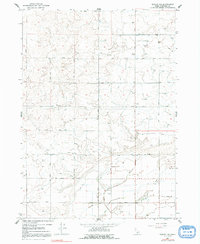
1964 Map of Burley NE
USGS Topo · Published 1991About this map
Agricultural development in the Snake River Plain is the primary focus of this Idaho survey, which documents an intricate network of irrigation and drainage infrastructure in Minidoka County. The landscape is defined by the Main Drain and engineered waterways like C-1 Canal and C-2 Canal, reflecting the mid-century transformation of arid lands into productive farmland. Settlement patterns follow a rigid grid of numbered routes, such as 900 North Road and 1000 West Road, that connect rural homesteads and vital community hubs.
Find a feature on this map
29 named features on this map. Tap any name to fly to it.
Don’t see what you’re looking for? This feature index may not catch every label — zoom into the map to look around manually.
Map Details
Editions of this 1964 Burley NE Map
2 editions found
Other maps of this area

1954 · Pocatello
USGS Topo · 1:250,000

1958 · Pocatello
USGS Topo · 1:250,000

1964 · Burley SW
USGS Topo · 1:24,000

1964 · Burley NE
USGS Topo · 1:24,000

1964 · Rupert NW
USGS Topo · 1:24,000

1964 · Burley NW
USGS Topo · 1:24,000

1964 · Rupert SW
USGS Topo · 1:24,000

1964 · Burley SE
USGS Topo · 1:24,000

1972 · Kimama
USGS Topo · 1:24,000
1972 · Kimama Butte
USGS Topo · 1:24,000