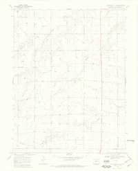
1969 Map of Burlington 3 NE
USGS Topo · Published 1973About this map
Middle Sandy Creek and Sandy Creek wind across this Kit Carson County landscape, illustrating the ephemeral drainage patterns of the High Plains. The terrain is defined by a series of north-south ridges separated by these watercourses, including Beaver Creek and Sand Creek. The distribution of numerous water wells across the township sections indicates a reliance on groundwater for agriculture and livestock in a semi-arid region. Human activity is largely limited to industrial and infrastructure markings, such as the Gravel Pits in the northwest and a network of section roads and fence lines. This map provides a detailed view of the rural plains shortly before the era of widespread center-pivot irrigation, capturing a landscape dominated by open range and dryland ranching operations.
Find a feature on this map
10 named features on this map. Tap any name to fly to it.
Don’t see what you’re looking for? This feature index may not catch every label — zoom into the map to look around manually.
Map Details
Editions of this 1969 Burlington 3 NE Map
2 editions found
Other maps of this area

1954 · Limon
USGS Topo · 1:250,000

1957 · Limon
USGS Topo · 1:250,000

1958 · Limon
USGS Topo · 1:250,000

1969 · Mount Sunflower SW
USGS Topo · 1:24,000

1969 · Burlington 3 SE
USGS Topo · 1:24,000

1969 · Bethune
USGS Topo · 1:24,000

1969 · Burlington
USGS Topo · 1:24,000

1969 · Mount Sunflower NW
USGS Topo · 1:24,000

1969 · Peconic
USGS Topo · 1:24,000

1969 · Burlington 3 NW
USGS Topo · 1:24,000