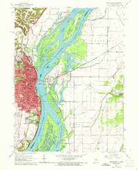
1964 Map of Burlington
USGS Topo · Published 1972About this map
The Mississippi River dominates this mid-century survey, dividing the urban landscape of Burlington, Iowa, from the complex alluvial islands and backwaters of Henderson County, Illinois. The river's dynamic nature is evidenced by features like Otter Island, Burlington Island, and numerous chutes and sloughs such as Rush Chute and Shokokon Slough. On the Iowa side, the city's growth is marked by a concentration of civic institutions, including Burlington Community College and several schools like Jefferson High Sch. The extensive grounds of Aspen Grove Cemetery and Dankwardt Memorial Park provide a green buffer within the residential grid, while the Chicago Burlington and Quincy railroad lines trace the industrial and transportation corridors that shaped the region's economy. The Illinois shoreline remains largely undeveloped, defined by recreational spots like Public Beach and small settlements such as Gulfport.
Find a feature on this map
87 named features on this map. Tap any name to fly to it.
Don’t see what you’re looking for? This feature index may not catch every label — zoom into the map to look around manually.
Map Details
Editions of this 1964 Burlington Map
Other maps of this area

1918 · La Harpe
USGS Topo · 1:62,500

1932 · Lomax
USGS Topo · 1:62,500

1934 · Oquawka
USGS Topo · 1:48,000

1934 · Burlington
USGS Topo · 1:48,000

1937 · Lomax
USGS Topo · 1:62,500

1940 · Oquawka
USGS Topo · 1:62,500

1940 · Burlington
USGS Topo · 1:62,500

1958 · Burlington
USGS Topo · 1:250,000

1961 · Burlington
USGS Topo · 1:250,000

1963 · Burlington
USGS Topo · 1:250,000