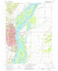
1964 Map of Burlington
USGS Topo · Published 1977About this map
The Mississippi River creates a complex landscape of braided channels and expansive islands in this mid-1960s study of the Iowa-Illinois border. On the western bluffs, Burlington is a dense urban center characterized by a high concentration of neighborhood schools, including North Hill Sch, Corse Sch, and Salter Sch. The city’s southern edge is defined by significant green spaces like Crapo Park and Dankwardt Memorial Park, which overlook the shifting waters of Sullivan Slough and Burlington Island. Across the river in Illinois, the environment shifts toward low-lying agricultural land and sloughs such as Mooney Pocket and Otter Bay. This contrast illustrates the historic development of a river city where the steep relief of the Flint Hills dictated early settlement patterns, while the eastern floodplain remained dedicated to drainage systems like the Diversion Ditch and small settlements like Gulfport.
Find a feature on this map
78 named features on this map. Tap any name to fly to it.
Don’t see what you’re looking for? This feature index may not catch every label — zoom into the map to look around manually.
Map Details
Editions of this 1964 Burlington Map
Other maps of this area

1918 · La Harpe
USGS Topo · 1:62,500

1932 · Lomax
USGS Topo · 1:62,500

1934 · Oquawka
USGS Topo · 1:48,000

1934 · Burlington
USGS Topo · 1:48,000

1937 · Lomax
USGS Topo · 1:62,500

1940 · Oquawka
USGS Topo · 1:62,500

1940 · Burlington
USGS Topo · 1:62,500

1958 · Burlington
USGS Topo · 1:250,000

1961 · Burlington
USGS Topo · 1:250,000

1963 · Burlington
USGS Topo · 1:250,000