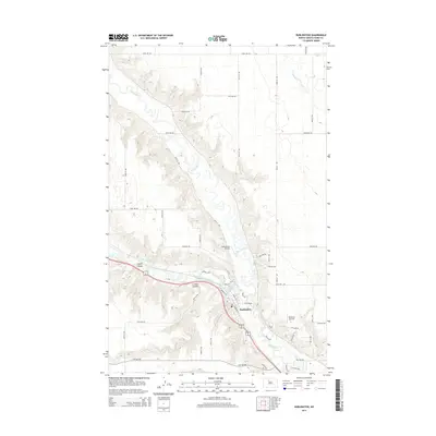
2014 Map of Burlington
USGS Topo · Published 2014About this map
Burlington serves as the focal point of this Ward County survey, situated at the significant confluence where the Des Lacs River joins the winding Souris River. The landscape is defined by the dramatic topography of the river valleys, carved by drainage features such as Lloyds Coulee and Larsons Coulee. These coulees create deep relief against the surrounding North Dakota plains, dictating the path of local transit and settlement. The map also documents a number of rural landing strips, including Pietschtree Airstrip to the north and Behrens Airstrip to the east, reflecting the regional reliance on aviation. A precise grid of section-line roads like 100th St NW and 62nd Ave NW connects the scattered farmsteads across the plateau, illustrating the enduring township-and-range organization of the prairie.
Find a feature on this map
32 named features on this map. Tap any name to fly to it.
Don’t see what you’re looking for? This feature index may not catch every label — zoom into the map to look around manually.
Map Details
Editions of this 2014 Burlington Map
This is the sole edition of this map. No revisions or reprints were ever made.
Other maps of this area

1928 · Minot
USGS Topo · 1:62,500

1948 · Burlington
USGS Topo · 1:24,000

1948 · Burlington
USGS Topo · 1:62,500

1948 · Minot NW
USGS Topo · 1:24,000

1949 · Burlington NW
USGS Topo · 1:24,000

1949 · Minot NW
USGS Topo · 1:24,000

1949 · Carpio NE
USGS Topo · 1:24,000

1949 · Burlington SE
USGS Topo · 1:24,000

1949 · Minot
USGS Topo · 1:24,000
1949 · Burlington NE
USGS Topo · 1:24,000