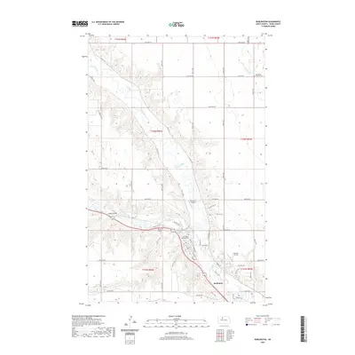
2020 Map of Burlington
USGS Topo · Published 2020About this map
The Souris River and the Des Lacs River converge near the town of Burlington, creating a landscape defined by sharp coulees and winding river valleys. This 2020 survey illustrates the modern layout of the community, where residential development transitions into the surrounding agricultural plateaus of Ward County. The map provides specific locations for local landmarks such as the Burlington Township Cem and the Emmanuel Lutheran Cem to the northeast, which are significant for family history research. Topographic details reveal the complex drainage patterns of the region, including Lloyds Coulee and Larsons Coulee, while local transportation is facilitated by routes like Co HWY 15 and Co HWY 10. Small private aviation sites, such as Pietschtree Airstrip and Behrens Airstrip, are also documented, reflecting the vast rural expanses between the river valleys.
Find a feature on this map
40 named features on this map. Tap any name to fly to it.
Don’t see what you’re looking for? This feature index may not catch every label — zoom into the map to look around manually.
Map Details
Editions of this 2020 Burlington Map
This is the sole edition of this map. No revisions or reprints were ever made.
Other maps of this area

1928 · Minot
USGS Topo · 1:62,500

1948 · Burlington
USGS Topo · 1:24,000

1948 · Burlington
USGS Topo · 1:62,500

1948 · Minot NW
USGS Topo · 1:24,000

1949 · Burlington NW
USGS Topo · 1:24,000

1949 · Minot NW
USGS Topo · 1:24,000

1949 · Carpio NE
USGS Topo · 1:24,000

1949 · Burlington SE
USGS Topo · 1:24,000

1949 · Minot
USGS Topo · 1:24,000
1949 · Burlington NE
USGS Topo · 1:24,000