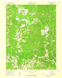
1957 Map of Burning Springs
USGS Topo · Published 1959About this map
The Little Kanawha River snakes through the heart of Wirt County in this late 1950s survey, illustrating a landscape deeply defined by the early petroleum industry. This region is home to Burning Springs, a site of significant historical importance as one of the earliest oil producing areas in the state. Numerous Oil Wells and Gas Wells are scattered across the ridges and hollows, particularly near Sanoma and Creston, indicating the persistent mineral extraction that shaped local development.
Find a feature on this map
92 named features on this map. Tap any name to fly to it.
Don’t see what you’re looking for? This feature index may not catch every label — zoom into the map to look around manually.
Map Details
Editions of this 1957 Burning Springs Map
2 editions found
Other maps of this area

1906 · Elizabeth
USGS Topo · 1:62,500

1907 · Harrisville
USGS Topo · 1:62,500

1907 · Arnoldsburg
USGS Topo · 1:62,500

1907 · Spencer
USGS Topo · 1:62,500

1924 · Harrisville
USGS Topo · 1:62,500

1924 · Elizabeth
USGS Topo · 1:62,500

1925 · Arnoldsburg
USGS Topo · 1:62,500

1926 · Elizabeth
USGS Topo · 1:62,500

1926 · Harrisville
USGS Topo · 1:62,500

1927 · Arnoldsburg
USGS Topo · 1:62,500