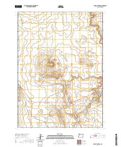
2020 Map of Burns Junction
USGS Topo · Published 2020About this map
Burns Junction serves as the primary landmark in this corner of Malheur County, situated where regional highways intersect amidst the high desert landscape. The terrain is defined by volcanic features and seasonal watercourses, most notably Scott Butte which rises centrally above the surrounding plains. A network of drainages including Scott Butte Cr and Palomino Cr carve through the landscape, feeding into the larger channel of Crooked Cr in the southeast. This modern survey reflects the sparse but vital infrastructure of the American West, where namesake tracks like Powell Rd and Crooked Creek Rd provide access across vast township sections. The map reveals a land management pattern dictated by water and topography, with features like Drought Cr suggesting the seasonal nature of the local environment.
Find a feature on this map
12 named features on this map. Tap any name to fly to it.
Don’t see what you’re looking for? This feature index may not catch every label — zoom into the map to look around manually.
Map Details
Editions of this 2020 Burns Junction Map
This is the sole edition of this map. No revisions or reprints were ever made.
Other maps of this area

1955 · Jordan Valley
USGS Topo · 1:250,000

1957 · Jordan Valley
USGS Topo · 1:250,000

1958 · Jordan Valley
USGS Topo · 1:250,000

1972 · Palomino Hills
USGS Topo · 1:24,000

1972 · Owyhee Butte
USGS Topo · 1:24,000
1972 · Palomino Lake
USGS Topo · 1:24,000

1972 · Rome
USGS Topo · 1:24,000
1972 · Iron Mountain
USGS Topo · 1:24,000
1972 · Burns Junction
USGS Topo · 1:24,000

1979 · Anderson Reservoir
USGS Topo · 1:24,000