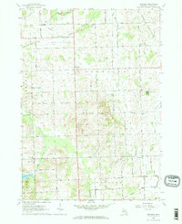
1963 Map of Burnside
USGS Topo · Published 1964About this map
The agricultural crossroads of Burnside serves as the focal point of this Lapeer County landscape during the early 1960s. The map reveals a tight-knit community structure defined by numerous country churches and schools, such as St Marys Ch and the Deanville Sch. The rural economy of the era is evident in the scattered Gravel Pits and the extensive network of drainage ditches like Cummings Drain and Gibbard Drain that managed the local water table for farming.
Find a feature on this map
38 named features on this map. Tap any name to fly to it.
Don’t see what you’re looking for? This feature index may not catch every label — zoom into the map to look around manually.
Map Details
Editions of this 1963 Burnside Map
2 editions found
Other maps of this area

1954 · Flint
USGS Topo · 1:250,000

1958 · Flint
USGS Topo · 1:250,000

1961 · Brown City
USGS Topo · 1:24,000
1961 · Capac
USGS Topo · 1:24,000

1963 · Clifford
USGS Topo · 1:24,000

1963 · Juhl
USGS Topo · 1:24,000

1963 · Attica
USGS Topo · 1:24,000

1963 · Marlette
USGS Topo · 1:24,000

1963 · North Branch
USGS Topo · 1:24,000

1963 · Burnside
USGS Topo · 1:24,000