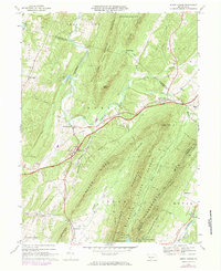
1966 Map of Burnt Cabins
USGS Topo · Published 1984About this map
Burnt Cabins and Fort Littleton anchor this mid-1960s study of the Ridge and Valley province, where the modern corridor of the Pennsylvania Turnpike cuts through a landscape defined by sharp mountain ridges. The geography is dominated by parallel summits such as Sideling Hill, Scrub Ridge, and Tuscarora Mountain, which hem in narrow valleys like Metal Valley. These gaps and notches have long dictated travel, with Interchange 13 and the historic Toll Road navigating the base of Sidneys Knob.
Find a feature on this map
55 named features on this map. Tap any name to fly to it.
Don’t see what you’re looking for? This feature index may not catch every label — zoom into the map to look around manually.
Map Details
Editions of this 1966 Burnt Cabins Map
Other maps of this area

1900 · Mercersburg
USGS Topo · 1:62,500

1902 · Mercersburg
USGS Topo · 1:62,500

1925 · Needmore
USGS Topo · 1:48,000

1930 · Broad Top
USGS Topo · 1:62,500

1933 · Broad Top
USGS Topo · 1:62,500

1935 · Needmore
USGS Topo · 1:62,500

1939 · Needmore
USGS Topo · 1:62,500

1939 · Orbisonia
USGS Topo · 1:62,500

1940 · Orbisonia
USGS Topo · 1:62,500

1942 · Hagerstown
USGS Topo · 1:125,000