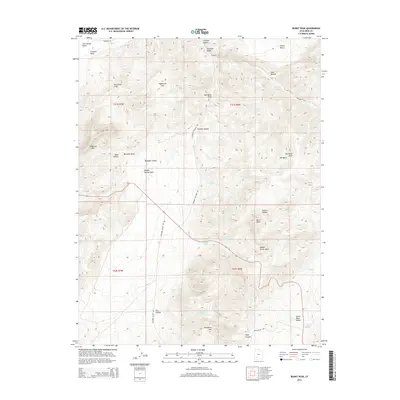
2014 Map of Burnt Peak
USGS Topo · Published 2014About this map
Hurricane Cliffs dominate the western edge of this Iron County landscape, where the high desert terrain transitions into a complex network of canyons and washes. The topographic detail highlights a region defined by water scarcity and seasonal drainage, anchored by the prominence of Burnt Peak and Anderson Mtn in the north. A web of unpaved tracks, including Freemont Rd and Buckskin Valley Rd, provides the only access through the alternating flats and breaks. Cultural and hydrological markers such as Lees Spring Wash, Lake Hollow, and Big Swamp Springs indicate the vital, albeit sparse, water sources that have historically supported ranching and transit across Buckskin Valley. From the broad expanse of Sagebrush Flat to the confined depths of Sackett Hollow, the map documents a geography where land use is dictated by the rise and fall of the high plateau.
Find a feature on this map
36 named features on this map. Tap any name to fly to it.
Don’t see what you’re looking for? This feature index may not catch every label — zoom into the map to look around manually.
Map Details
Editions of this 2014 Burnt Peak Map
This is the sole edition of this map. No revisions or reprints were ever made.
Other maps of this area

1885 · Beaver
USGS Topo · 1:250,000

1886 · Kanab
USGS Topo · 1:250,000

1953 · Richfield
USGS Topo · 1:250,000

1953 · Cedar City
USGS Topo · 1:250,000

1958 · Richfield
USGS Topo · 1:250,000

1958 · Cedar City
USGS Topo · 1:250,000

1962 · Cedar City
USGS Topo · 1:250,000

1966 · Fremont Pass
USGS Topo · 1:24,000

1966 · Panguitch NW
USGS Topo · 1:24,000

1971 · Buckhorn Flat
USGS Topo · 1:24,000