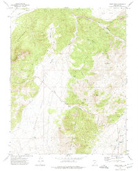
1971 Map of Burnt Peak
USGS Topo · Published 1974About this map
Hurricane Cliffs dominate the northwestern corner of this Iron County landscape, marking a sharp topographic transition in the high desert terrain. The area is defined by a network of drainage systems and isolated peaks, including Anderson Mtn and the namesake Burnt Peak. Water sources are critical in this environment, evidenced by numerous named springs such as Far Hollow Spring, Robb Spring, and Big Swamp Springs that emerge from the various hollows and basins.
Find a feature on this map
33 named features on this map. Tap any name to fly to it.
Don’t see what you’re looking for? This feature index may not catch every label — zoom into the map to look around manually.
Map Details
Editions of this 1971 Burnt Peak Map
This is the sole edition of this map. No revisions or reprints were ever made.
Other maps of this area

1885 · Beaver
USGS Topo · 1:250,000

1886 · Kanab
USGS Topo · 1:250,000

1953 · Richfield
USGS Topo · 1:250,000

1953 · Cedar City
USGS Topo · 1:250,000

1958 · Richfield
USGS Topo · 1:250,000

1958 · Cedar City
USGS Topo · 1:250,000

1962 · Cedar City
USGS Topo · 1:250,000

1966 · Fremont Pass
USGS Topo · 1:24,000

1966 · Panguitch NW
USGS Topo · 1:24,000

1971 · Buckhorn Flat
USGS Topo · 1:24,000