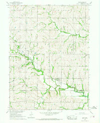
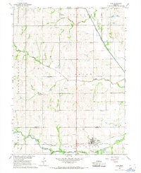
1966 Map of Burr
USGS Topo · Published 1968About this map
Burr sits at the center of this mid-1960s agricultural landscape, where the Missouri Pacific railroad follows the valley of the South Fork Little Nemaha River. This topography is defined by its drainages, including Muddy Creek, Little Muddy Cr, and Saunders Creek, which cut through the townships of South Palmyra, South Russell, South Branch, and Sterling. Local family history and genealogy are anchored by several rural burial grounds such as Dughman Cem, Hope Cem, and Wilson Cem, alongside the Hopewell Ch. The map captures the infrastructure of the era, from the local Sewage Disposal Ponds and a Sandpit to a significant Pipeline corridor. The border between Otoe County and Johnson County runs through the southern portion of the sheet, dividing these farming communities.
Find a feature on this map
21 named features on this map. Tap any name to fly to it.
Don’t see what you’re looking for? This feature index may not catch every label — zoom into the map to look around manually.
Map Details
Editions of this 1966 Burr Map
This is the sole edition of this map. No revisions or reprints were ever made.
Other maps of this area

1903 · Weeping Water
USGS Topo · 1:125,000

1929 · Weeping Water
USGS Topo · 1:125,000

1955 · Lincoln
USGS Topo · 1:250,000

1957 · Lincoln
USGS Topo · 1:250,000

1958 · Lincoln
USGS Topo · 1:250,000

1965 · Sterling
USGS Topo · 1:24,000
1965 · Douglas
USGS Topo · 1:24,000
1965 · Tecumseh NW
USGS Topo · 1:24,000
1965 · St. Mary
USGS Topo · 1:24,000
1966 · Cook
USGS Topo · 1:24,000