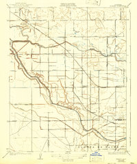
1927 Map of Burrel
USGS Topo · Published 1942About this map
Fresno Slough winds through the heart of this Central Valley agricultural landscape, defining the local topography alongside Murphy Stough. The 1924 field survey reveals a region transitioning through large-scale land holdings like Burrel Ranch and West Lake Ranch, while the grid of irrigation ditches and section-line roads such as Mt Whitney Avenue and Elkhorn Avenue organize the terrain.
Find a feature on this map
39 named features on this map. Tap any name to fly to it.
Don’t see what you’re looking for? This feature index may not catch every label — zoom into the map to look around manually.
Map Details
Editions of this 1927 Burrel Map
3 editions found
Other maps of this area

1912 · Coalinga
USGS Topo · 1:125,000

1924 · Riverdale
USGS Topo · 1:31,680

1925 · Helm
USGS Topo · 1:31,680

1925 · Raisin
USGS Topo · 1:31,680

1925 · Caruthers
USGS Topo · 1:31,680

1926 · Lethent
USGS Topo · 1:31,680

1927 · Burrel
USGS Topo · 1:31,680

1927 · Riverdale
USGS Topo · 1:31,680

1927 · Lemoore
USGS Topo · 1:31,680

1931 · Wheatville
USGS Topo · 1:31,680