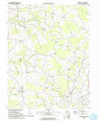
1993 Map of Burrsville
USGS Topo · Published 1993About this map
Burrsville and Whiteleysburg anchor a landscape defined by the intersection of the Maryland-Delaware border and the Caroline and Kent county lines. The terrain is a network of agricultural crossroads and small rural settlements, including Schultie Crossroads, Hollandsville, and Brownsville. Numerous unnamed cemeteries and rural churches like Manship Ch, Union Ch, and Wesley Ch are scattered throughout the quadrangle, indicating a deeply rooted community infrastructure.
Find a feature on this map
65 named features on this map. Tap any name to fly to it.
Don’t see what you’re looking for? This feature index may not catch every label — zoom into the map to look around manually.
Map Details
Editions of this 1993 Burrsville Map
This is the sole edition of this map. No revisions or reprints were ever made.
Other maps of this area

1899 · Dover
USGS Topo · 1:125,000

1905 · Denton
USGS Topo · 1:62,500

1905 · Barclay
USGS Topo · 1:62,500

1906 · Dover
USGS Topo · 1:125,000

1918 · Harrington
USGS Topo · 1:62,500

1920 · Dover
USGS Topo · 1:125,000

1926 · Wyoming
USGS Topo · 1:48,000

1930 · Wyoming
USGS Topo · 1:62,500

1931 · Wyoming
USGS Topo · 1:62,500

1944 · Denton
USGS Topo · 1:31,680