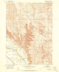
1952 Map of Burwell SE
USGS Topo · Published 1954About this map
The North Loup River valley dominates this early 1950s landscape, serving as the primary corridor for transport and irrigation in Garfield County. Along its northern banks, the Burwell Sumter Canal runs parallel to the river, a vital piece of water infrastructure developed for the Missouri River Basin. The agrarian character of the region is evident in the dense network of rural schoolhouses, including Rosehill Sch, Richland Sch, and Banner Sch, which were the social anchors for farming families in the Willow Springs and Midvale areas.
Find a feature on this map
20 named features on this map. Tap any name to fly to it.
Don’t see what you’re looking for? This feature index may not catch every label — zoom into the map to look around manually.
Map Details
Editions of this 1952 Burwell SE Map
3 editions found
Other maps of this area

1952 · Burwell
USGS Topo · 1:24,000

1952 · Elyria
USGS Topo · 1:24,000

1952 · Burwell SE
USGS Topo · 1:24,000

1952 · Burwell NE
USGS Topo · 1:24,000

1952 · Comstock NW
USGS Topo · 1:24,000

1952 · Burwell NW
USGS Topo · 1:24,000

1954 · Gables SW
USGS Topo · 1:24,000

1954 · Ord NW
USGS Topo · 1:24,000

1954 · Gables NW
USGS Topo · 1:24,000

1955 · Broken Bow
USGS Topo · 1:250,000