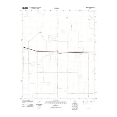
2010 Map of Bushland
USGS Topo · Published 2010About this map
Bushland serves as the central hub of this High Plains landscape, situated along a major east-west transportation corridor. The terrain to the north is defined by the drainage of Tecovas Creek and Spring Creek, which wind through the plains toward features like the Tecovas Pond Dam. Rising above the surrounding flatlands, Goat Mountain provides a distinct topographic landmark in the northern portion of the quadrangle. The map captures a moment of transition for the community, where traditional section-line roads like W Co Rd 34 and W Farmers Ave intersect with newer residential developments represented by streets such as White Tail Ave and Laramie. This grid-iron network of county roads and family-named drives, including Bezner Dr and Blessen Dr, illustrates the steady expansion of rural homesteads and agricultural infrastructure on the outskirts of the Texas Panhandle.
Find a feature on this map
27 named features on this map. Tap any name to fly to it.
Don’t see what you’re looking for? This feature index may not catch every label — zoom into the map to look around manually.
Map Details
Editions of this 2010 Bushland Map
This is the sole edition of this map. No revisions or reprints were ever made.
Other maps of this area

1934 · Ady
USGS Topo · 1:62,500

1934 · Cliffside
USGS Topo · 1:62,500

1936 · Cliffside
USGS Topo · 1:62,500

1936 · Ady
USGS Topo · 1:62,500

1953 · Cliffside
USGS Topo · 1:24,000

1954 · Tucumcari
USGS Topo · 1:250,000

1954 · Amarillo
USGS Topo · 1:250,000

1958 · Amarillo
USGS Topo · 1:250,000

1958 · Tucumcari
USGS Topo · 1:250,000
1960 · Amarillo West
USGS Topo · 1:24,000