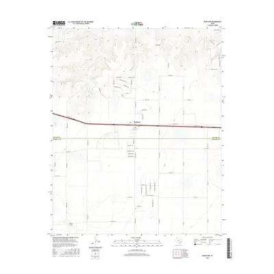
2016 Map of Bushland
USGS Topo · Published 2016About this map
Bushland sits at a geographic transition where the High Plains of the Texas Panhandle meet the drainage breaks of the Canadian River valley. The community is anchored by its Po and defined by the path of Interstate 40, which separates the more densely gridded residential lanes from the open ranch land to the north. This area is marked by numerous ephemeral water features and drainages, including the headwaters of Tecovas Cr and Spring Cr, alongside distinctive relief features like Goat Mtn. The landscape reflects a modern rural-suburban hybrid, where traditional cattle-country markers like Frying Pan Rd and Negro Arroyo intersect with newer residential developments characterized by naming conventions like Prairie Wind Rd and Indian Spring Trl. Notable landmarks such as Ida Lake and Tecovas Pond highlight the importance of water management in this arid environment.
Find a feature on this map
62 named features on this map. Tap any name to fly to it.
Don’t see what you’re looking for? This feature index may not catch every label — zoom into the map to look around manually.
Map Details
Editions of this 2016 Bushland Map
This is the sole edition of this map. No revisions or reprints were ever made.
Other maps of this area

1934 · Ady
USGS Topo · 1:62,500

1934 · Cliffside
USGS Topo · 1:62,500

1936 · Cliffside
USGS Topo · 1:62,500

1936 · Ady
USGS Topo · 1:62,500

1953 · Cliffside
USGS Topo · 1:24,000

1954 · Tucumcari
USGS Topo · 1:250,000

1954 · Amarillo
USGS Topo · 1:250,000

1958 · Amarillo
USGS Topo · 1:250,000

1958 · Tucumcari
USGS Topo · 1:250,000
1960 · Amarillo West
USGS Topo · 1:24,000