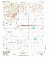
1984 Map of Bushland
USGS Topo · Published 1984About this map
Bushland serves as a central hub on this West Texas landscape, where the agricultural and industrial character of the High Plains is clearly visible. The survey documents a transition in local infrastructure, notably featuring an Old Railroad Grade and an Elevator that anchor the settlement's transport history. Beyond the town, the land is marked by significant resource extraction and scientific research, including a large Cement Plant, multiple Quarry sites, and a Tailings Pond north of the community. Near the intersection of the Potter Co Randall Co line, the map identifies specialized facilities such as an Experiment Station and a Weather Station, which speak to the area's long-standing connection to agricultural development. Water management is evidenced through features like Ida Lake and the winding paths of Spring Creek and Tecovas Creek carved into the panhandle terrain.
Find a feature on this map
17 named features on this map. Tap any name to fly to it.
Don’t see what you’re looking for? This feature index may not catch every label — zoom into the map to look around manually.
Map Details
Editions of this 1984 Bushland Map
This is the sole edition of this map. No revisions or reprints were ever made.
Other maps of this area

1934 · Ady
USGS Topo · 1:62,500

1934 · Cliffside
USGS Topo · 1:62,500

1936 · Cliffside
USGS Topo · 1:62,500

1936 · Ady
USGS Topo · 1:62,500

1953 · Cliffside
USGS Topo · 1:24,000

1954 · Tucumcari
USGS Topo · 1:250,000

1954 · Amarillo
USGS Topo · 1:250,000

1958 · Amarillo
USGS Topo · 1:250,000

1958 · Tucumcari
USGS Topo · 1:250,000
1960 · Amarillo West
USGS Topo · 1:24,000