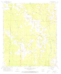
1960 Map of Bussey
USGS Topo · Published 1973About this map
The Kansas City Southern railroad cuts a straight path through the center of this terrain, anchoring the small settlements of Bussey and Experiment. This 1960 field-checked landscape is defined by the burgeoning energy industry of southern Arkansas, dominated by the Mc Kamie Patton Oil Field in the west and the Dorcheat Macedonia Oil Field to the east. These industrial zones are interspersed with established community landmarks, including the Woodard Sch and several rural congregations such as Friendship Ch and Sharman Ch. The natural geography is shaped by the winding course of Bayou Dorcheat and its tributaries like Bridge Creek, which create a complex drainage pattern across the Georgia and Buena Vista regions. This survey captures a moment when traditional agricultural settlements and local cemeteries like Rocky Mount Cem existed alongside intensive mid-century oil extraction.
Find a feature on this map
33 named features on this map. Tap any name to fly to it.
Don’t see what you’re looking for? This feature index may not catch every label — zoom into the map to look around manually.
Map Details
Editions of this 1960 Bussey Map
3 editions found
Other maps of this area

1952 · Bradley NE
USGS Topo · 1:24,000

1952 · Lewisville
USGS Topo · 1:24,000

1952 · Bradley SE
USGS Topo · 1:24,000

1953 · El Dorado
USGS Topo · 1:250,000

1957 · El Dorado
USGS Topo · 1:250,000

1958 · El Dorado
USGS Topo · 1:250,000

1960 · El Dorado
USGS Topo · 1:250,000

1960 · Bussey
USGS Topo · 1:24,000
1960 · Taylor
USGS Topo · 1:24,000

1960 · Walkerville
USGS Topo · 1:24,000