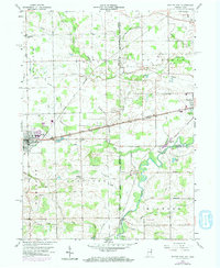
1958 Map of Butler East
USGS Topo · Published 1974About this map
St Joseph River meanders through the landscape of the Indiana-Ohio border during this mid-century period. The map highlights a rural environment defined by drainage ditches and small agrarian settlements like Artic, Stafford Center, and Edgerton. Infrastructure of the era is prominently marked by the Norfolk and Western and Penn Central railroads, which intersect at the town of Butler. Small country institutions, such as Big Run Ch and the Jerusalem School, point to the localized social hubs that served farming families. The presence of numerous burial grounds, including Maple Grove Cem, Farnham Cem, and Clarksville Cem, provides a detailed record for genealogical research in both DeKalb and Williams counties. Topographic revisions from 1973 are layered over the original 1958 survey, showing the subtle evolution of residential growth near the town limits.
Find a feature on this map
37 named features on this map. Tap any name to fly to it.
Don’t see what you’re looking for? This feature index may not catch every label — zoom into the map to look around manually.
Map Details
Editions of this 1958 Butler East Map
4 editions found

Other maps of this area

1914 · Pioneer
USGS Topo · 1:62,500

1914 · Bryan
USGS Topo · 1:62,500

1939 · Hamilton
USGS Topo · 1:24,000

1940 · Metz
USGS Topo · 1:24,000

1943 · Bryan
USGS Topo · 1:62,500

1944 · Pioneer
USGS Topo · 1:62,500

1948 · Hamilton
USGS Topo · 1:24,000

1953 · Fort Wayne
USGS Topo · 1:250,000

1956 · Fort Wayne
USGS Topo · 1:250,000

1958 · Hicksville
USGS Topo · 1:24,000