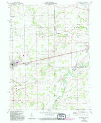
1958 Map of Butler East
USGS Topo · Published 1994About this map
Butler serves as the primary hub in this late-1950s landscape, where the agricultural plains of northeast Indiana meet the Ohio border. The settlement of Artic and the rural crossroads of Stafford Center anchor the surrounding townships of Stafford, Wilmington, and Troy, providing a detailed view of the region's mid-century rural infrastructure. A distinct network of water management is evident through numerous ditches and runs, including the winding course of Fish Creek and Big Run, which eventually give way to the St Joseph River in the southeast corner.
Find a feature on this map
36 named features on this map. Tap any name to fly to it.
Don’t see what you’re looking for? This feature index may not catch every label — zoom into the map to look around manually.
Map Details
Editions of this 1958 Butler East Map
4 editions found

Other maps of this area

1914 · Pioneer
USGS Topo · 1:62,500

1914 · Bryan
USGS Topo · 1:62,500

1939 · Hamilton
USGS Topo · 1:24,000

1940 · Metz
USGS Topo · 1:24,000

1943 · Bryan
USGS Topo · 1:62,500

1944 · Pioneer
USGS Topo · 1:62,500

1948 · Hamilton
USGS Topo · 1:24,000

1953 · Fort Wayne
USGS Topo · 1:250,000

1956 · Fort Wayne
USGS Topo · 1:250,000

1958 · Hicksville
USGS Topo · 1:24,000