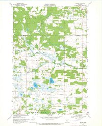
1969 Map of Butler
USGS Topo · Published 1971About this map
The Redeye River and Kettle River meander through this landscape on the border of Becker and Otter Tail Counties, characterizing a region defined by its glacial hydrology and dispersed rural settlements. In the late 1960s, the community of Butler serves as a local focal point, anchored by the Holy Cross Ch. The map reveals a transition from the agricultural clearings of Spruce Grove and Runeberg in the north to the protected wetlands of the Bluff Creek State Wildlife Management Area in the south. Genealogists and local historians can locate specific landmarks like the Paddock-Bethel Cem and the small cluster at Hillview, while the numerous Gravel Pits and the presence of Mud Lake speak to the area's post-glacial terrain and local industrial resources.
Find a feature on this map
16 named features on this map. Tap any name to fly to it.
Don’t see what you’re looking for? This feature index may not catch every label — zoom into the map to look around manually.
Map Details
Editions of this 1969 Butler Map
This is the sole edition of this map. No revisions or reprints were ever made.
Other maps of this area

1953 · Brainerd
USGS Topo · 1:250,000

1957 · Brainerd
USGS Topo · 1:250,000

1958 · Brainerd
USGS Topo · 1:250,000

1965 · Brainerd
USGS Topo · 1:250,000

1969 · Wolf Lake
USGS Topo · 1:24,000

1969 · Sebeka SW
USGS Topo · 1:24,000

1969 · Evergreen
USGS Topo · 1:24,000

1969 · Park Rapids SW
USGS Topo · 1:24,000

1969 · New York Mills NW
USGS Topo · 1:24,000

1969 · Sebeka NW
USGS Topo · 1:24,000