
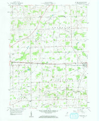
1958 Map of Butler West
USGS Topo · Published 1959About this map
Agricultural life in DeKalb County during the late 1950s is anchored by the rail crossing at Butler, where the New York Central Railroad meets the Grand Trunk Western RR. This transportation nexus supported a rural landscape defined by township blocks such as Wilmington and Grant, crisscrossed by a network of drainage ditches including Donnell and Varner. The map reveals a high density of local institutions that served the farmstead economy, from the Franklin Center Sch to country congregations at Norris Chapel and Mt Pleasant Ch. Genealogists will find a wealth of family-named landmarks and small burial grounds, such as Haverstock Cem, Lutz Cem, and Rude Cem, which document the settlement patterns of northeast Indiana before modern consolidation altered these tight-knit communities.
Find a feature on this map
37 named features on this map. Tap any name to fly to it.
Don’t see what you’re looking for? This feature index may not catch every label — zoom into the map to look around manually.
Map Details
Editions of this 1958 Butler West Map
2 editions found
Other maps of this area

1939 · Hamilton
USGS Topo · 1:24,000

1940 · Metz
USGS Topo · 1:24,000

1942 · Ashley
USGS Topo · 1:24,000

1948 · Hamilton
USGS Topo · 1:24,000

1953 · Fort Wayne
USGS Topo · 1:250,000

1956 · Fort Wayne
USGS Topo · 1:250,000

1957 · Auburn
USGS Topo · 1:24,000

1957 · Waterloo
USGS Topo · 1:24,000

1958 · Hicksville
USGS Topo · 1:24,000
1958 · Saint Joe
USGS Topo · 1:24,000