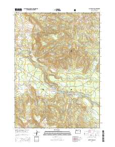
2014 Map of Butte Falls
USGS Topo · Published 2014About this map
The town of Butte Falls serves as the central hub of this landscape, situated near the namesake Falls where the N Fork Big Butte Cr and South Fork Big Butte Creek converge. Much of the surrounding territory is managed as the Rogue River National Forest, characterized by prominent elevations like Santiam Peak and Fredenburg Butte. The map reveals a complex network of forestry and access roads, many designated by Bureau of Land Management codes such as BLM 34-2e-9, which weave through the timbered ridges.
Find a feature on this map
91 named features on this map. Tap any name to fly to it.
Don’t see what you’re looking for? This feature index may not catch every label — zoom into the map to look around manually.
Map Details
Editions of this 2014 Butte Falls Map
This is the sole edition of this map. No revisions or reprints were ever made.
Other maps of this area

1891 · Ashland
USGS Topo · 1:250,000

1893 · Ashland
USGS Topo · 1:250,000

1897 · Ashland
USGS Topo · 1:250,000

1938 · Medford
USGS Topo · 1:125,000

1954 · Butte Falls
USGS Topo · 1:62,500

1954 · Lakecreek
USGS Topo · 1:62,500

1955 · Rustler Peak
USGS Topo · 1:62,500

1955 · Mt. Mc Loughlin
USGS Topo · 1:62,500

1955 · Medford
USGS Topo · 1:250,000

1957 · Medford
USGS Topo · 1:250,000