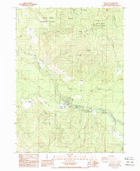
1988 Map of Butte Falls
USGS Topo · Published 1988About this map
Butte Falls serves as the central hub of this Jackson County landscape, situated at the confluence where the North Fork Big Butte Creek and South Fork Big Butte Creek meet. The area’s infrastructure is defined by the Medford Aqueduct winding across the terrain and the presence of the N F R R line in the southeast. Significant family-named landmarks such as Fredenburg Ranch and Fredenburg Butte suggest the deep-rooted agricultural and ranching history of the region.
Find a feature on this map
33 named features on this map. Tap any name to fly to it.
Don’t see what you’re looking for? This feature index may not catch every label — zoom into the map to look around manually.
Map Details
Editions of this 1988 Butte Falls Map
This is the sole edition of this map. No revisions or reprints were ever made.
Other maps of this area

1891 · Ashland
USGS Topo · 1:250,000

1893 · Ashland
USGS Topo · 1:250,000

1897 · Ashland
USGS Topo · 1:250,000

1938 · Medford
USGS Topo · 1:125,000

1954 · Butte Falls
USGS Topo · 1:62,500

1954 · Lakecreek
USGS Topo · 1:62,500

1955 · Rustler Peak
USGS Topo · 1:62,500

1955 · Mt. Mc Loughlin
USGS Topo · 1:62,500

1955 · Medford
USGS Topo · 1:250,000

1957 · Medford
USGS Topo · 1:250,000