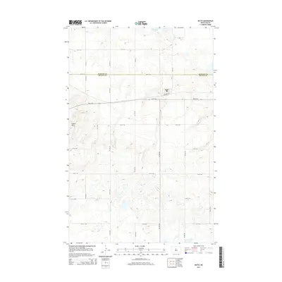
2014 Map of Butte
USGS Topo · Published 2014About this map
Butte sits atop the high ground of the Missouri Coteau, where the border between McHenry Co and McLean Co marks the landscape. This 2014 survey captures the settlement's relationship with the prominent elevation of Dogden Butte to the southwest, a landmark that defines the local topography. To the north, Cottonwood Lake provides a natural counterpoint to the orderly grid of section roads like 30th St N and 24th St NW. The presence of Railroad Ave within the town center points to the historical importance of rail transport in shaping this prairie community, even as modern state and county routes like CR-33 serve as the primary conduits for travel through this agricultural region.
Find a feature on this map
15 named features on this map. Tap any name to fly to it.
Don’t see what you’re looking for? This feature index may not catch every label — zoom into the map to look around manually.
Map Details
Editions of this 2014 Butte Map
This is the sole edition of this map. No revisions or reprints were ever made.
Other maps of this area

1929 · Kongsberg
USGS Topo · 1:62,500

1929 · Balfour
USGS Topo · 1:62,500

1945 · Pelican Lake
USGS Topo · 1:62,500

1947 · Pelican Lake
USGS Topo · 1:62,500

1947 · Turtle Lake
USGS Topo · 1:62,500

1954 · McClusky
USGS Topo · 1:250,000

1958 · McClusky
USGS Topo · 1:250,000

1958 · Butte
USGS Topo · 1:24,000
1958 · Kongsberg NE
USGS Topo · 1:24,000
1958 · Balfour NW
USGS Topo · 1:24,000