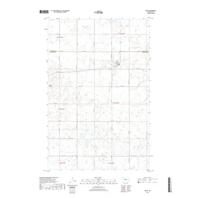
2018 Map of Butte
USGS Topo · Published 2018About this map
Butte sits atop the boundary of McLean and McHenry counties, anchoring a landscape of glacial depressions and prairie rises in central North Dakota. The town is laid out on a grid that includes 2nd Ave, 3rd Ave, and 4th Ave, serving as a local hub for the surrounding agricultural community. To the west, the prominent elevation of Dogden Butte rises above the plains, providing a significant geographical landmark for the region. The map captures the area's rural character, characterized by Numerous small wetlands and seasonal basins that dot the sections between the county line and Cottonwood Lake to the north. Genealogists and local historians can locate the Butte Cem north of the main settlement, while the extensive network of section-line roads like 30th St NW and 29th St NW illustrates the enduring layout of the Public Land Survey System in this part of the state.
Find a feature on this map
23 named features on this map. Tap any name to fly to it.
Don’t see what you’re looking for? This feature index may not catch every label — zoom into the map to look around manually.
Map Details
Editions of this 2018 Butte Map
This is the sole edition of this map. No revisions or reprints were ever made.
Other maps of this area

1929 · Kongsberg
USGS Topo · 1:62,500

1929 · Balfour
USGS Topo · 1:62,500

1945 · Pelican Lake
USGS Topo · 1:62,500

1947 · Pelican Lake
USGS Topo · 1:62,500

1947 · Turtle Lake
USGS Topo · 1:62,500

1954 · McClusky
USGS Topo · 1:250,000

1958 · McClusky
USGS Topo · 1:250,000

1958 · Butte
USGS Topo · 1:24,000
1958 · Kongsberg NE
USGS Topo · 1:24,000
1958 · Balfour NW
USGS Topo · 1:24,000