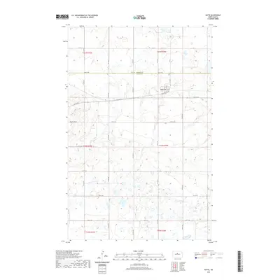
2020 Map of Butte
USGS Topo · Published 2020About this map
Butte sits near the county line where McHenry and McLean counties meet, serving as a focal point in a landscape defined by prairie potholes and glacial topography. This modern 2020 survey illustrates the town's grid, centered around Railroad Ave and 3rd Ave, highlighting its enduring structure on the North Dakota plains. North of the town center, the Butte Cem rests along 30th St N, while the prominent rise of Dogden Butte stands out to the west, a landmark that likely guided travelers long before the formal section lines were established. The map reveals the meticulous township and range system, showing how roads like 28th St NW and 24th St NW partition the land into productive agricultural blocks punctuated by numerous seasonal wetlands.
Find a feature on this map
23 named features on this map. Tap any name to fly to it.
Don’t see what you’re looking for? This feature index may not catch every label — zoom into the map to look around manually.
Map Details
Editions of this 2020 Butte Map
This is the sole edition of this map. No revisions or reprints were ever made.
Other maps of this area

1929 · Kongsberg
USGS Topo · 1:62,500

1929 · Balfour
USGS Topo · 1:62,500

1945 · Pelican Lake
USGS Topo · 1:62,500

1947 · Pelican Lake
USGS Topo · 1:62,500

1947 · Turtle Lake
USGS Topo · 1:62,500

1954 · McClusky
USGS Topo · 1:250,000

1958 · McClusky
USGS Topo · 1:250,000

1958 · Butte
USGS Topo · 1:24,000
1958 · Kongsberg NE
USGS Topo · 1:24,000
1958 · Balfour NW
USGS Topo · 1:24,000