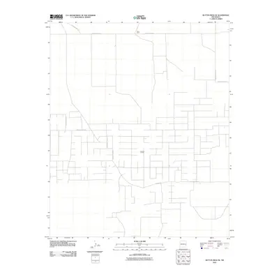
2010 Map of Button Mesa NE
USGS Topo · Published 2010About this map
The Chaveroo Oil Field dominates this eastern New Mexico landscape, characterized by a dense network of industrial access roads and utility corridors. Unlike traditional agricultural or residential grids, the infrastructure here is dictated by energy extraction, with numerous unnamed spur roads branching off the primary thoroughfares. The most prominent landmarks are tied to the local ranching and extraction economy, including the Tucker Ranch situated along the northern boundary.
Find a feature on this map
11 named features on this map. Tap any name to fly to it.
Don’t see what you’re looking for? This feature index may not catch every label — zoom into the map to look around manually.
Map Details
Editions of this 2010 Button Mesa NE Map
This is the sole edition of this map. No revisions or reprints were ever made.
Other maps of this area

1954 · Brownfield
USGS Topo · 1:250,000

1958 · Brownfield
USGS Topo · 1:250,000

1962 · Brownfield
USGS Topo · 1:250,000

1972 · Milnesand SW
USGS Topo · 1:24,000

1972 · Dora SW
USGS Topo · 1:24,000
1972 · Milnesand NW
USGS Topo · 1:24,000

1978 · Flying M Ranch
USGS Topo · 1:24,000

1978 · Button Mesa North
USGS Topo · 1:24,000
1979 · Schram Lake
USGS Topo · 1:24,000
1979 · Elida SE
USGS Topo · 1:24,000