
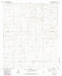
1972 Map of Milnesand SW
USGS Topo · Published 1975About this map
Vandiver Oil Field stretches across the high plains of Eastern New Mexico, defining the industrial character of this desert landscape in the early 1970s. The map captures an era of active petroleum extraction along the border of Roosevelt and Lea Counties, where a dense network of Oil Wells, Drill Holes, and Pumping Stations are the primary markers of human activity. The lack of named settlements or permanent towns emphasizes the remote, specialized nature of this district, which functioned as a workspace for the regional energy industry.
Find a feature on this map
10 named features on this map. Tap any name to fly to it.
Don’t see what you’re looking for? This feature index may not catch every label — zoom into the map to look around manually.
Map Details
Editions of this 1972 Milnesand SW Map
2 editions found
Other maps of this area

1954 · Brownfield
USGS Topo · 1:250,000

1958 · Brownfield
USGS Topo · 1:250,000

1961 · Johnson Ranch
USGS Topo · 1:24,000

1962 · Brownfield
USGS Topo · 1:250,000

1970 · Johnson Ranch
USGS Topo · 1:24,000

1970 · Ranger Lake
USGS Topo · 1:24,000

1972 · Milnesand
USGS Topo · 1:24,000

1972 · Crossroads
USGS Topo · 1:24,000
1972 · Milnesand NW
USGS Topo · 1:24,000
1973 · Lane Salt Lake
USGS Topo · 1:24,000