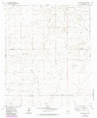
1972 Map of Milnesand SW
USGS Topo · Published 1985About this map
The Vada Oil Field dominates this High Plains landscape, illustrating the industrial footprint of petroleum extraction in eastern New Mexico during the early 1970s. Spanning the boundary between Roosevelt and Lea counties, the area is defined by a dense network of energy infrastructure, including numerous oil wells and several pumping stations. A systematic grid of pipelines connects these extraction points, weaving through a terrain otherwise marked by scattered gravel pits and exploratory drill holes. The map captures a transition period in the region's energy economy, where traditional land use meets intensive industrial development. The stark arrangement of wells and transport lines provides a detailed look at the rural industrialization that characterized the Llano Estacado during this era of domestic energy expansion.
Find a feature on this map
12 named features on this map. Tap any name to fly to it.
Don’t see what you’re looking for? This feature index may not catch every label — zoom into the map to look around manually.
Map Details
Editions of this 1972 Milnesand SW Map
2 editions found
Other maps of this area

1954 · Brownfield
USGS Topo · 1:250,000

1958 · Brownfield
USGS Topo · 1:250,000

1961 · Johnson Ranch
USGS Topo · 1:24,000

1962 · Brownfield
USGS Topo · 1:250,000

1970 · Johnson Ranch
USGS Topo · 1:24,000

1970 · Ranger Lake
USGS Topo · 1:24,000

1972 · Milnesand SW
USGS Topo · 1:24,000

1972 · Milnesand
USGS Topo · 1:24,000

1972 · Crossroads
USGS Topo · 1:24,000
1972 · Milnesand NW
USGS Topo · 1:24,000