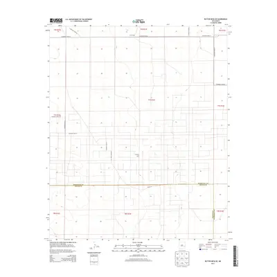
2013 Map of Button Mesa NE
USGS Topo · Published 2013About this map
Chaveroo Oil Field dominates the center of this high plains landscape, illustrating the industrial footprint of petroleum extraction in eastern New Mexico. The terrain is organized by a strict rectilinear grid of rural thoroughfares, including S Roosevelt Road 35 and S Roosevelt Road 39, which cut across the sparsely populated border between Roosevelt and Chaves Counties. The presence of Tucker Ranch in the northern reaches of the quadrangle serves as a reminder of the region's enduring ranching heritage alongside its mineral economy. Bisecting the lower half of the map, Reserve Rd provides a primary east-west corridor through the undulating topography. This 2013 survey by the U.S. Geological Survey details a landscape where industrial energy infrastructure and traditional land use meet at the edge of the Llano Estacado.
Find a feature on this map
23 named features on this map. Tap any name to fly to it.
Don’t see what you’re looking for? This feature index may not catch every label — zoom into the map to look around manually.
Map Details
Editions of this 2013 Button Mesa NE Map
This is the sole edition of this map. No revisions or reprints were ever made.
Other maps of this area

1954 · Brownfield
USGS Topo · 1:250,000

1958 · Brownfield
USGS Topo · 1:250,000

1962 · Brownfield
USGS Topo · 1:250,000

1972 · Milnesand SW
USGS Topo · 1:24,000

1972 · Dora SW
USGS Topo · 1:24,000
1972 · Milnesand NW
USGS Topo · 1:24,000

1978 · Flying M Ranch
USGS Topo · 1:24,000

1978 · Button Mesa North
USGS Topo · 1:24,000
1979 · Schram Lake
USGS Topo · 1:24,000
1979 · Elida SE
USGS Topo · 1:24,000