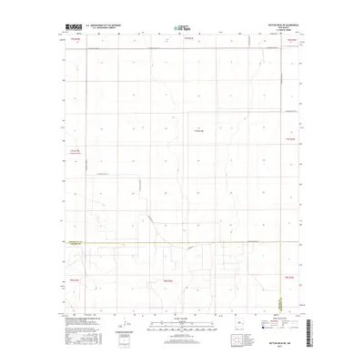
2017 Map of Button Mesa NE
USGS Topo · Published 2017About this map
High plains terrain and a rigid section-line road network characterize this 2017 survey of the borderlands between Roosevelt County and Chaves County. This area of eastern New Mexico is defined by its expansive ranching and agricultural grid, where long stretches of unpaved paths like S Roosevelt Road 35 and S Roosevelt Road Ac facilitate movement across the open landscape. The map provides a precise look at the township and range system, including t7s r33e and t8s r33e, which organizes the territory into a clear geometric pattern. The presence of Reserve Rd near the southern county line suggests localized utility or access points within the larger livestock-grazing environment that dominates this region.
Find a feature on this map
22 named features on this map. Tap any name to fly to it.
Don’t see what you’re looking for? This feature index may not catch every label — zoom into the map to look around manually.
Map Details
Editions of this 2017 Button Mesa NE Map
This is the sole edition of this map. No revisions or reprints were ever made.
Other maps of this area

1954 · Brownfield
USGS Topo · 1:250,000

1958 · Brownfield
USGS Topo · 1:250,000

1962 · Brownfield
USGS Topo · 1:250,000

1972 · Milnesand SW
USGS Topo · 1:24,000

1972 · Dora SW
USGS Topo · 1:24,000
1972 · Milnesand NW
USGS Topo · 1:24,000

1978 · Flying M Ranch
USGS Topo · 1:24,000

1978 · Button Mesa North
USGS Topo · 1:24,000
1979 · Schram Lake
USGS Topo · 1:24,000
1979 · Elida SE
USGS Topo · 1:24,000