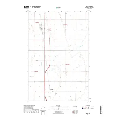
2018 Map of Buxton
USGS Topo · Published 2018About this map
Buxton and Cummings serve as the primary hubs in this section of Traill County, North Dakota, where the landscape is defined by the steady, north-south passage of 162 Ave NE and the winding course of Buffalo Coulee. The town of Buxton shows a structured grid with residential streets such as Greely St, Neill St, and Ives St framing the central Broadway corridor. Further south, Cummings sits at the junction of Front St and 7th St NE, reflecting the area's agricultural settlement pattern. Local history and genealogy are anchored by several community landmarks, including East Immanuel Cem to the northeast and Reeves Cem just east of Buxton. The region is tied together by a network of county roads like Co Hwy 21 and Co Hwy 17, which provide vital connections across the flat plains.
Find a feature on this map
28 named features on this map. Tap any name to fly to it.
Don’t see what you’re looking for? This feature index may not catch every label — zoom into the map to look around manually.
Map Details
Editions of this 2018 Buxton Map
This is the sole edition of this map. No revisions or reprints were ever made.
Other maps of this area

1918 · Kelso
USGS Topo · 1:62,500

1918 · Hendrum
USGS Topo · 1:62,500

1919 · Eldred
USGS Topo · 1:62,500

1943 · Kelso
USGS Topo · 1:62,500

1952 · Grand Forks
USGS Topo · 1:250,000

1956 · Grand Forks
USGS Topo · 1:250,000

1963 · Hillsboro
USGS Topo · 1:24,000

1964 · Climax NW
USGS Topo · 1:24,000

1964 · Climax SW
USGS Topo · 1:24,000
1964 · Caledonia
USGS Topo · 1:24,000