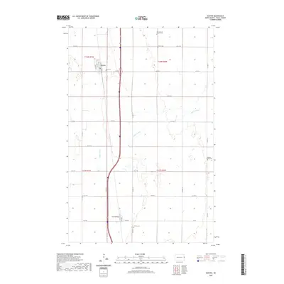
2020 Map of Buxton
USGS Topo · Published 2020About this map
Buxton and Cummings anchor this agricultural landscape in eastern North Dakota, situated along a prominent north-south transportation corridor. The map reveals a high density of rural burial sites, including East Immanuel Lutheran Cem, Pioneer Cem, Reeves Cem, and Highland Lutheran Cem, reflecting the deep-rooted settlement history of the Red River Valley. The meandering path of Buffalo Coulee cuts through the surveyed grid of section lines, providing a natural contrast to the rigid geometry of the surrounding farmland. Tracing the layout of Buxton, one can find the local street names such as Greely St and Broadway, while the small settlement of Cummings is located further south near Cummings Cem. The area is defined by a dense network of county roads, including Co Hwy 21 and Co Hwy 17, which facilitate the movement of local trade through these prairie townships.
Find a feature on this map
33 named features on this map. Tap any name to fly to it.
Don’t see what you’re looking for? This feature index may not catch every label — zoom into the map to look around manually.
Map Details
Editions of this 2020 Buxton Map
This is the sole edition of this map. No revisions or reprints were ever made.
Other maps of this area

1918 · Kelso
USGS Topo · 1:62,500

1918 · Hendrum
USGS Topo · 1:62,500

1919 · Eldred
USGS Topo · 1:62,500

1943 · Kelso
USGS Topo · 1:62,500

1952 · Grand Forks
USGS Topo · 1:250,000

1956 · Grand Forks
USGS Topo · 1:250,000

1963 · Hillsboro
USGS Topo · 1:24,000

1964 · Climax NW
USGS Topo · 1:24,000

1964 · Climax SW
USGS Topo · 1:24,000
1964 · Caledonia
USGS Topo · 1:24,000