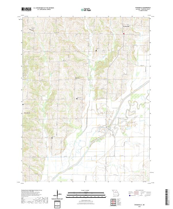
2021 Map of Bynumville
USGS Topo · Published 2021About this map
The Chariton River meanders through the central and southern reaches of this landscape, its winding channel shaping the rural character of eastern Chariton County. The unincorporated settlement of Bynumville anchors the northern portion of the map, while Hamden and Musselfork mark other points of historical habitation in this agricultural corridor. Local heritage is preserved in several small burial grounds, including Fitzgerald Cem, Fairview Cem, and Pee Dee Cem, which are tucked away along the network of county roads. The terrain is defined by numerous drainage systems, such as Jones Br, Elm Br, and the various branches of Bee Branch, including E Bee Br and W Bee Br. Near the northwestern corner, Slaughter Airport stands out as a modern landmark amidst the traditional farmsteads and creek valleys that have long characterized this part of Missouri.
Find a feature on this map
64 named features on this map. Tap any name to fly to it.
Don’t see what you’re looking for? This feature index may not catch every label — zoom into the map to look around manually.
Map Details
Editions of this 2021 Bynumville Map
This is the sole edition of this map. No revisions or reprints were ever made.
Other maps of this area

1890 · Glasgow
USGS Topo · 1:125,000

1953 · Moberly
USGS Topo · 1:250,000

1953 · Marceline
USGS Topo · 1:24,000

1953 · Clifton Hill
USGS Topo · 1:24,000

1953 · Prairie Hill
USGS Topo · 1:24,000

1953 · Lagonda
USGS Topo · 1:24,000

1953 · Wien
USGS Topo · 1:24,000

1953 · Bynumville
USGS Topo · 1:24,000
1953 · Mike
USGS Topo · 1:24,000

1954 · Moberly
USGS Topo · 1:250,000