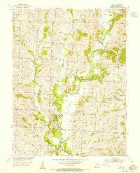
1953 Map of Mike
USGS Topo · Published 1955About this map
The winding course of Mussel Fork defines this portion of the northern Missouri landscape, meandering through Musselfork and Keytesville townships. At the time of this mid-century survey, the rural community structure remained centered on local landmarks such as St Joseph Ch and Corinth Ch, alongside the Pollard Sch. Small settlements like Mike and Pat are situated away from the major watercourses, while Yellow Creek and Long Branch drain the surrounding terrain. Genealogists can find several family-linked burial sites, including Lock Cem and Welch Cem, which are preserved alongside a solitary Quarry in the northwest. The map captures a moment when the transition from purely agrarian settlement patterns was documented by the Geological Survey and Department of the Interior in the early 1950s.
Find a feature on this map
22 named features on this map. Tap any name to fly to it.
Don’t see what you’re looking for? This feature index may not catch every label — zoom into the map to look around manually.
Map Details
Editions of this 1953 Mike Map
2 editions found
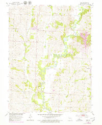
Other maps of this area

1890 · Glasgow
USGS Topo · 1:125,000

1890 · Marshall
USGS Topo · 1:125,000

1892 · Marshall
USGS Topo · 1:125,000

1901 · Marshall
USGS Topo · 1:125,000

1949 · Indian Grove
USGS Topo · 1:24,000

1949 · Rothville
USGS Topo · 1:24,000

1950 · Rothville
USGS Topo · 1:24,000

1951 · Brunswick East
USGS Topo · 1:24,000

1953 · Moberly
USGS Topo · 1:250,000

1953 · Marceline
USGS Topo · 1:24,000