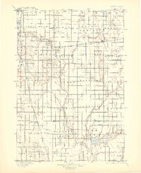
1895 Map of Byron
USGS Topo · Published 1904About this map
The James River meanders southward through the center of this prairie landscape, carving a distinct valley through the townships of Lincoln, Cornwall, and Pleasant View. Surveyed in the late 19th century, the map reveals a burgeoning rail-and-river economy anchored by the Chicago and Northwestern R. R., which connects the grain-belt settlements of Doland, Frankfort, and Crandon.
Find a feature on this map
44 named features on this map. Tap any name to fly to it.
Don’t see what you’re looking for? This feature index may not catch every label — zoom into the map to look around manually.
Map Details
Editions of this 1895 Byron Map
4 editions found
Other maps of this area

1894 · Conde
USGS Topo · 1:62,500

1895 · Byron
USGS Topo · 1:125,000

1895 · Aberdeen
USGS Topo · 1:125,000

1898 · Huron
USGS Topo · 1:125,000

1899 · Northville
USGS Topo · 1:125,000

1899 · Redfield
USGS Topo · 1:125,000

1899 · De Smet
USGS Topo · 1:125,000

1950 · Wessington NE
USGS Topo · 1:24,000

1953 · Frankfort
USGS Topo · 1:24,000

1953 · Redfield North
USGS Topo · 1:24,000