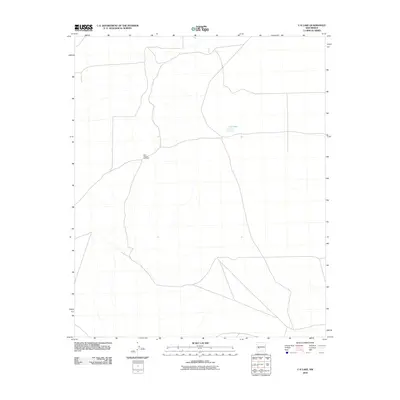
2010 Map of C-N Lake
USGS Topo · Published 2010About this map
C-N Lake sits at the heart of this sparsely settled landscape in Catron County, New Mexico. The geography here is defined by an expansive network of unimproved roads and drainage paths that reveal a pastoral economy reliant on water management in a high-desert environment. A single named landmark, the West Pasture Windmill, serves as a critical navigation point and functional infrastructure piece for local ranching operations. The terrain is marked by subtle shifts in elevation and seasonal water features, illustrating the isolation and specialized land use patterns typical of the region in the early 21st century.
Find a feature on this map
2 named features on this map. Tap any name to fly to it.
Don’t see what you’re looking for? This feature index may not catch every label — zoom into the map to look around manually.
Map Details
Editions of this 2010 C-N Lake Map
This is the sole edition of this map. No revisions or reprints were ever made.
Other maps of this area

1954 · Tularosa
USGS Topo · 1:250,000

1954 · Socorro
USGS Topo · 1:250,000

1958 · Socorro
USGS Topo · 1:250,000

1958 · Tularosa
USGS Topo · 1:250,000

1962 · Socorro
USGS Topo · 1:250,000

1963 · Anderson Peak
USGS Topo · 1:24,000

1965 · Oak Peak
USGS Topo · 1:24,000
1965 · Sugarloaf Mountain
USGS Topo · 1:24,000
1965 · Kellog Well
USGS Topo · 1:24,000
1965 · Augustine Well
USGS Topo · 1:24,000