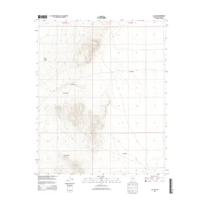
2013 Map of C-N Lake
USGS Topo · Published 2013About this map
Plains of San Agustin defines the high-altitude topography of this Catron County landscape as it appeared in 2013. The map details a predominantly open basin, where subtle elevation changes are marked by isolated features like the West Pasture Windmill. This specific area reflects the ranching and hydrological patterns of western New Mexico, centered around the ephemeral C-N Lake. Produced by the U.S. Geological Survey, the survey provides precise contouring across the township and range boundaries of t4s r10w and t4s r9w, illustrating the sparse but deliberate human infrastructure required for land management in this arid terrain.
Find a feature on this map
9 named features on this map. Tap any name to fly to it.
Don’t see what you’re looking for? This feature index may not catch every label — zoom into the map to look around manually.
Map Details
Editions of this 2013 C-N Lake Map
This is the sole edition of this map. No revisions or reprints were ever made.
Other maps of this area

1954 · Tularosa
USGS Topo · 1:250,000

1954 · Socorro
USGS Topo · 1:250,000

1958 · Socorro
USGS Topo · 1:250,000

1958 · Tularosa
USGS Topo · 1:250,000

1962 · Socorro
USGS Topo · 1:250,000

1963 · Anderson Peak
USGS Topo · 1:24,000

1965 · Oak Peak
USGS Topo · 1:24,000
1965 · Sugarloaf Mountain
USGS Topo · 1:24,000
1965 · Kellog Well
USGS Topo · 1:24,000
1965 · Augustine Well
USGS Topo · 1:24,000