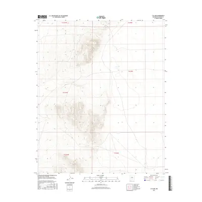
2017 Map of C-N Lake
USGS Topo · Published 2017About this map
C-N Lake lies within the high-altitude terrain of western New Mexico, situated at the boundary of several United States Public Land Survey System townships including t4s r9w and t4s r10w. This remote section of Catron County is characterized by a landscape of volcanic peaks and ridges, including the slopes of Sugarloaf Mountain and Anderson Peak as noted in the adjoining quadrangle indices. The survey reveals a sparse human footprint in this corner of the state, where the primary features are the natural hydrology of the lake and the precise grid of the t5s r9w and t5s r10w boundaries. The mapping illustrates the complex topographic contours of the Luera Mountains, providing an essential record of the area's geography and drainage patterns before modern digital elevation models.
Find a feature on this map
7 named features on this map. Tap any name to fly to it.
Don’t see what you’re looking for? This feature index may not catch every label — zoom into the map to look around manually.
Map Details
Editions of this 2017 C-N Lake Map
This is the sole edition of this map. No revisions or reprints were ever made.
Other maps of this area

1954 · Tularosa
USGS Topo · 1:250,000

1954 · Socorro
USGS Topo · 1:250,000

1958 · Socorro
USGS Topo · 1:250,000

1958 · Tularosa
USGS Topo · 1:250,000

1962 · Socorro
USGS Topo · 1:250,000

1963 · Anderson Peak
USGS Topo · 1:24,000

1965 · Oak Peak
USGS Topo · 1:24,000
1965 · Sugarloaf Mountain
USGS Topo · 1:24,000
1965 · Kellog Well
USGS Topo · 1:24,000
1965 · Augustine Well
USGS Topo · 1:24,000